

Opinion
Original town plat, McCook
Monday, November 26, 2012
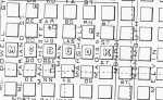
Lincoln Land Co. plat of Original McCook 1882
Thanks to efforts of one local historian, the Red Willow County Clerk's office will soon have a fine new, large, easy to read, black on white copy of the Lincoln Land Company's first plat of the Original Town of McCook, supplementing the fragile, white on black, hard to read plat of Original McCook that is presently available for study at the Red Willow County Clerk's office.
Dave Stenzel, who lives in Bartley, but works in McCook, has always had a deep interest in history, especially local history, and over the years has collected many historical artifacts of this area. Recently, he acquired, via the internet, a beautiful, 18" X 20" print of the Original Town, which he plans to replicate and present to the people of Red Willow County.
In 1882 the Burlington Railroad building program was nearing McCook on its way to establishing service between Lincoln and Denver. There was much talk about a needed Division Point in this area. There was no reason to suppose that there needed to be a new town established in this area to accommodate that Division Point. Indianola and Culbertson, both well-established towns on the proposed rail route, certainly did not think so. At that time there were factions in both towns who were busy promoting the merits of their city for the new Division Point, bound to make the city chosen into a much bigger, more important place.
Ryan & Turner's plat of McCook in 1886
The Lincoln Land Company was a business that was formed and run by officials of the Burlington Railroad, but operated as a separate entity from the railroad. This company preceded the railroad in its "march to the west," buying up probable town sites along the railroad's right of way (using insider information?). McCook was one of these town sites, owned by the Lincoln Land Co., and Alexander Campbell was its agent in this area. Over time, the Lincoln Land Co. acquired a tremendous amount of choice land adjacent to the railroad, and could exert a great deal of influence on the railroad's operations. In 1882, as the railway approached, the Lincoln Land Company dictated that Fairview, a tiny spot on the south bank of the Republican, and located along the railroad's right of way, would be bypassed, in favor of an adjacent, new town, north of the river. Later, the Company was used its influence to have the new RR terminal, McCook (named for Mr. Campbell's friend, Civil War Hero, Alexander McCook), chosen as a Division Point for the Burlington line, much to the disappointment of more established cities, like Indianola and Culbertson.
According to the Lincoln Land Co. plat, McCook streets running east and west all started with the letter "D", the streets running north and south all began with the letter "M." The original city of McCook consisted of some 30 blocks, extending from three blocks east of Main Avenue, (because it was wider than other streets), and three blocks west of Main Avenue. From south to north the original town extended from the railroad tracks north to what is now "F" street. The street paralleling the railroad on the north (now "A" Street) was North Railroad Street.
Though the reason for naming a certain street cannot always be explained, several of the names can be linked to a historical person or place.
Dodge Street was named for Augustus Caesar Dodge, United States Senator from Iowa, who introduced the bill to organize the territory of Nebraska in 1853.
Dodge County, Nebraska was also named after him, as was an important street in Omaha.
Douglas Street honored Senator Stephen A. Douglas, the architect of the Kansas-Nebraska Act (and Abraham Lincoln's worthy opponent in the Lincoln-Douglas debates.)
Dakota Street honored the Dakota (Sioux) Indians, as did Dakota City, Nebraska.
Many early pioneers to Nebraska came from Iowa and Illinois, thus Dearborn and Dennison Streets came because of the association with those cities "from back home."
Marshall Street was named to honor Chief Justice John Marshall, the fourth Chief Justice, who served in the Supreme Court from 1790 until his death in 1835.
Madison and Monroe Streets probably honored the fourth and fifth Presidents of the United States. However, there are some who believe that Madison Street was named to honor H. Madison, one of the very early settlers in Red Willow County.
McDowell was the middle name of the man who lent his name to McCook, General Alexander McDowell McCook, and a great friend of our Alexander Campbell.
A St. -- North Railroad St.
East 3rd St. -- Monroe St.
| B St. -- Dennison St. |
East 2nd St. -- Madison St.
| C St. -- Dodge St. |
East 1st St. -- Marshall St.
| D St. -- Douglas St. |
Norris Ave. -- Main Avenue.
| E. St. -- Dearborn St. |
West 1st St. -- Manchester St.
F. St.---Dakota St.
West 2nd St. -- McFarland St.
West 3rd St. -- McDowell St.
In the early years Marshall St. (East 1st), with its fine view of the Republican Valley and the hills beyond, was the most prestigious address and a number of large, grand homes of leading businessmen were built here -- Hiram Clapp, H.P. Waite, and A. Barnett, to mention just a few.
Over the next 100 years over 70 additions were added to this original town.
| Some of the additions -- West McCook, East McCook, and South McCook originally were very much like separate towns, with all of the rivalry associated with separate cities, but by 1886 South McCook and West McCook had been added as additions to the original city. The names of the new streets in West McCook went along with the "M" and "D" concept. In West McCook, Manitoba Avenue was the name for the present Federal Avenue (the street going south under the Railroad Tracks, connecting South McCook with McCook. Going west from there, the North/South streets in West McCook were Minnesota, Maryland, Michigan, Missouri, and Mississippi. East/West Streets were Dennison (which was not a through street), Delaware, and Dawson. |
For some reason, in 1886, when South McCook was added to the city, civic officials did not choose to continue the practice of naming streets with names beginning with "D" and "M". Instead, in South McCook the east/west streets were 1st Street, 2nd Street, and 3rd Street, while the north/south streets were designated "A", "B", and "C", just opposite of the way streets were named beginning in 1908, and are still used that way today.
Since 1908, the naming of streets, as subdivisions have been added, has varied, though the names of the original streets have not been changed, with the exception of Main Avenue, which was changed to Norris Avenue to honor Senator George Norris shortly after his death in 1944.
It may be that naming streets after numbers and letters of the alphabet is an efficient way to simplify finding an address, yet it does not produce the little pleasure that comes as one journeys through Northeast McCook and views the street names in the "Reservation"---names which honor the various Indian tribes that played such an important role in our nation's history, and most of all to drive down McCook's principal artery and recall for a fleeting moment the memory of George Norris, the man who is honored across the nation, but is appreciated in McCook as a man who never forgot his old hometown.