
Hail storms and flooding impact city
McCOOK, Neb. — Official records from the National Weather Service at McCook Municipal Airport (KMCK) show the city was pounded Tuesday by more than five inches of rain along with destructive hail. The deluge, logged in six-hour totals that peaked overnight, far exceeded the norm for a single late-summer storm.
Severe storms typically move with the steering winds aloft, so when a system seems to stall or park over one place, meteorologists look for specific setups:
-Weak upper-level winds: If the jet stream is sluggish or distant, storms may lack the push to move along.
- Boundary interactions: Outflow boundaries, stationary fronts, or converging winds at the surface can repeatedly trigger new cells in the same spot, a process called training.
-Mesoscale organization: Sometimes a supercell will “anchor” along a boundary, redeveloping as old updrafts collapse, so hail and rain keep forming over nearly the same area.
-Propagation vs. motion: A storm may drift slowly, but the location where it redevelops can stay fixed — making it feel like it’s not moving at all.
That seems to have been the case in McCook: radar suggested the warned supercell regenerated multiple times along its own outflow, keeping hail and heavy rain squarely over the city for nearly two hours.
Timeline
The first official hail reports came in at 1954 UTC (2:54 p.m. CDT), when quarter-sized hail was said to be ongoing southwest of McCook, with enough ice accumulating on the ground to be noticeable. Just six minutes later, at 2000 UTC (3:00 p.m. CDT), the size was upgraded west of town to 2.5 inches, though the record was quickly corrected, reflecting the rapid pace at which reports were being relayed.
By 2040 UTC (3:40 p.m. CDT), trained spotters were confirming one-inch stones to the southwest, but the storm intensified again almost immediately. At 2050 UTC (3:50 p.m. CDT), another correction west of McCook confirmed stones up to 2.75 inches.
The hail then moved directly over the city. At 2103 UTC (4:03 p.m. CDT), social media reports began to describe “golf ball-sized” stones within McCook itself. Just five minutes later, at 2108 UTC (4:08 p.m. CDT), a trained spotter southwest of town measured a full three inches.
By 2114 UTC (4:14 p.m. CDT), damage reports were already being relayed — roof damage caused by ping-pong ball-sized hail. One minute later, at 2115 UTC (4:15 p.m. CDT), members of the public were measuring two-inch stones within McCook city limits.
As the storm lingered, dramatic photos emerged. At 2138 UTC (4:38 p.m. CDT), a photo documented a single hailstone estimated at 3.1 inches northwest of town. At 2151 UTC (4:51 p.m. CDT), yet another report of “golf ball-sized hail” confirmed the storm’s persistence.
The catalog of descriptions grew even more colorful: by 2155 UTC (4:55 p.m. CDT), observers using the mPING app were recording “Hen Egg+” hail — estimated at 2.25 inches. Just after the turn of the hour, at 2204 UTC (5:04 p.m. CDT), the same network noted a return to quarter-sized hail, suggesting fluctuations in intensity.
But the storm had not finished. At 2217 UTC (5:17 p.m. CDT), hail east of McCook was again measured at “Hen Egg” size, about two inches across. A minute later, at 2218 UTC (5:18 p.m. CDT), reports west-southwest of town confirmed hail was “still falling.”
Late reports underscore the storm’s longevity: at 2242 UTC (5:42 p.m. CDT), stones southwest of town were measured at 3.4 inches, picked up from the ground after the storm’s peak.
At 2243 UTC (5:43 p.m. CDT), just moments after the earlier peak report, a measurement two miles west of McCook confirmed hailstones reaching 3.15 inches in diameter. Accompanying photographs documented vehicle damage — a windshield caved in and a small side window shattered — underscoring the destructive force of the storm.
As the hail threat gradually subsided, the storm’s second act became apparent in the form of flooding rains. By 0103 UTC (8:03 p.m. CDT), the official McCook ASOS had already logged nearly four inches of rainfall, with other gauges west and northwest of town recording between three and five inches in the same period. Draws within city limits ran nearly a foot deep by late evening, with water surging down streets and prompting public reports of flash flooding.
Overnight, totals continued to climb. A mesonet site three miles west-northwest of McCook reported 5.08 inches by 0155 UTC (8:55 p.m. CDT), while another gauge six miles west-northwest measured 3.18 inches just minutes later. Cooperative and volunteer observers later confirmed the scope of the deluge: by 1200 UTC (6:00 a.m. MDT), a CO-OP site north of town had tallied 5.98 inches in 24 hours, while a CoCoRaHS observer to the north measured 5.73 inches, and another southwest of McCook logged 3.33 inches.
By sunrise on September 17, the combined record told the story of a storm that had evolved from a crippling hail event into one of the most intense single-day rainfalls in memory for the McCook area — a reminder that even as the stones stopped falling, the hazards were far from over.
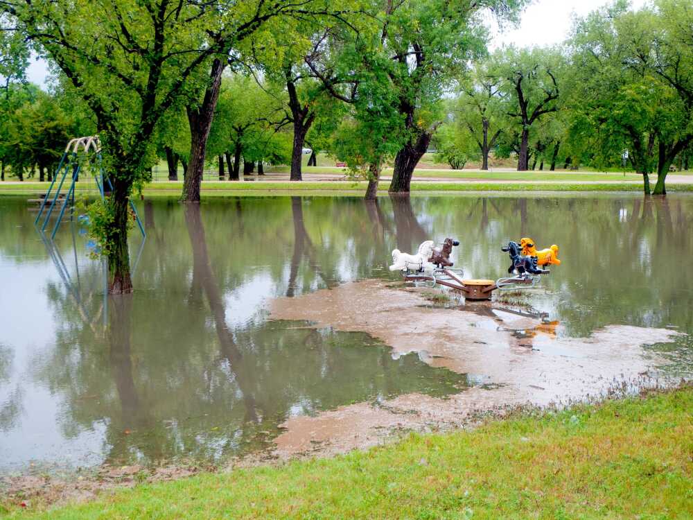
Around town, the storm’s unusual persistence over the city proved devastating, cracking windshields, denting vehicles “like golf balls,” shredding roofs, and shattering windows. The impact rippled across town on Wednesday, including the closure of Barnett Park due to damage and flooding, as residents and authorities began to tally losses from a night that combined record rainfall with relentless hail.
Anecdotal reports suggest substantial damage to crops, but as of press time, neither the USDA nor the Nebraska Department of Agriculture, University of Nebraska–Lincoln Extension, or local farm organizations had issued formal statements regarding crop damage from the storm. Those will be reported as they become available.
According to Grant Otten of NPPD, there were no large customer outages in McCook from the storm, but there was some damage to street lights. There may have been momentary “blips” due to safety mechanisms in the distribution system, but no outages were long-lasting.
Otten encouraged customers who have damage to their meters or power line structure to contact NPPD.
The City of McCook had scheduled a long-planned office closure Wednesday for a software upgrade, which delayed contractor license processing until the next day. The timing proved unfortunate, coinciding with peak demand from roofing companies responding to storm damage, leaving contractors to wait until Thursday to complete applications after filing the required online form.
McCook Fire Chief Marc Harpham commented on the storm, saying, “We had several calls during the storm and several of the fire department vehicles received damage from the hail.”
When asked if city residents responded to calls for safety, Harpham said, “The community responded very well to the weather.”
Harpham also praised his staff, particularly those in the communications center. “Our communications center was overwhelmed with calls, and they, as always, did an amazing job of prioritizing the emergency calls that we responded to during the storm.”