
Rainfed corn moving into critical period
From my perspective, this is the worst I've seen it this time of year, in my lifetime ... and I've been around for a while. I know it's hard to explain, because fallow wheat yields reported in the 80-bushel range during this years' harvest, were not that uncommon.
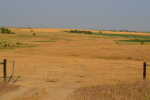
Rainfed crops, that's right! University agronomists started using the term rainfed rather than dryland, are beyond the point of no return. Perhaps we should use the term un-rainfed or non-rainfed, but dryland works just as well for me.
Summer has just begun, and it already resembles conditions as they generally appear in late August. Much of this can be attributed to the fact that many locations have received less than an inch and a half of rain during all of May and June, and thus far, July.
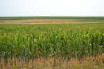
Drought has taken hold as the corn crop goes into pollination -- a critical time for water.
Much of the dryland corn won't even tassel and silk to give it the opportunity to pollinate.
With the non-stop high temperatures, high winds, high solar radiation and low relative humidity, the combination makes it hard to keep up with corn's moisture demands, even with irrigation.
A huge factor, along with record setting temperatures almost every day for the last month, has been the relentless wind. Wind demands moisture, causing corn plants to start rolling their leaves to conserve moisture. According to Al Dutcher, state climatologist at the University of Nebraska-Lincoln, "A 10-mile-per-hour wind can usually be offset by the corn's canopy," "But anything faster than that increases the airflow through the full canopy and subsequently increases surface evaporation and transpiration."
"When ET values get above .40 of an inch, it is difficult for corn to physically move that much water through its leaves."
All of our crops, pastures, and even trees started their growth far ahead of the normal growing season and have been using water for an additional month causing late summer conditions to appear during June.
"The Climate Prediction Center's 30-day forecast indicates all of Nebraska should experience above normal temperatures. They also are indicating below normal precipitation for the eastern two-thirds of Nebraska, east/southeastward through central Illinois," Dutcher said.
"The highest probability of below normal precipitation has been assigned to the eastern one-third of the state. Even though, Western Nebraska has not been assigned a precipitation tendency for July, the U.S. Drought Monitor outlook for the next three months shows little relief. It also indicates areas currently depicted as experiencing normal conditions, will likely experience drought conditions within the next three months."
Here's wishing everyone a nice, cool, rainfed county fair.